project logo OSGeo Project

GeoTools

GeoTools jest otwart? (LGPL) bibliotek? Java, kt?ra dostarcza zgodnych ze sandardami metod do przetwarzania danych geoprzestrzennych. U?ywa ona struktur danych opartych o specyfikacje Open Geospatial Consortium (OGC).

GeoTools is a modular library supported by plugins for additional formats

GeoTools znajduje zastosowanie w wielu projektach, w??czaj?c us?ugi sieciowe, narz?dzia wiersza polece? i aplikacje desktopowe. Aplikacje OSGeo-Live, kt?re u?ywaj? GeoTools, to: 52°North SOS, 52°North WPS, AtlasStyler, Geomajas, Geopublisher, GeoServer, and User-friendly Desktop Internet GIS (uDig).

G??wne funkcje

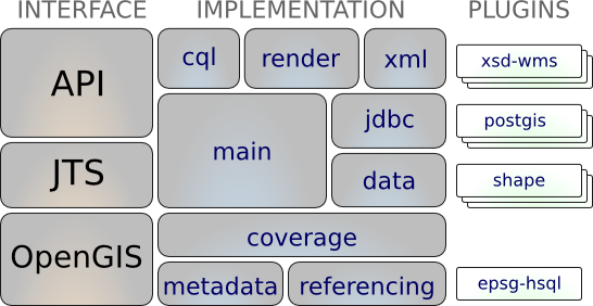
  • Definition of interfaces for key spatial concepts and data structures

    • Integrated Geometry support provided by JTS Topology Suite (JTS)
    • Attribute and spatial filters using OGC Filter Encoding specification
  • A clean data access API supporting feature access, transaction support and locking between threads

    • Access GIS data in many file formats and spatial databases
    • Coordinate reference system and transformation support
    • Work with an extensive range of map projections
    • filter and analyze data in terms of spatial and non-spatial attributes
  • A stateless, low memory renderer, particularly useful in server-side environments.

    • compose and display maps with complex styling
  • Powerful schema assisted parsing technology using XML Schema to bind to GML content

    • The parsing / encoding technology is provided with bindings for many OGC standards including GML, Filter, KML, SLD, and SE.
  • GeoTools Plugins: open plug-in system allowing you to teach the library additional formats

    • Plug-ins for the ImageIO-EXT project allowing GeoTools to read additional raster formats from GDAL
  • GeoTools Extensions

    • Provide additional capabilities built using the spatial facilites of the core library.
    Extensions built using the GeoTools library
    • Extensions provide graph and networking support (for finding the shortest path), validation, a web map server client, bindings for xml parsing and encoding and color brewer.
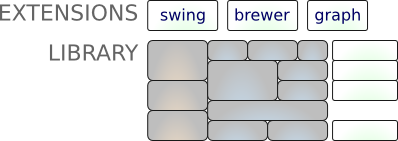
  • GeoTools Unsupported

    • GeoTools also operates as part of a wider community with a staging area used to foster new talent and promote experimentation.
    • Some highlights are swing support (used in geotools tutorials), swt, local and web process support, additional symbology, additional data formats, generation of grids and a couple of implementations of ISO Geometry.

Obs?ugiwane formaty

  • raster formats and data access:

    arcsde, arcgrid, geotiff, grassraster, gtopo30, image (JPEG, TIFF, GIF, PNG), imageio-ext-gdal, imagemoasaic, imagepyramid, JP2K, matlab.

  • Database “jdbc-ng” support:

    db2, h2, mysql, oracle, postgis, spatialite, sqlserver.

  • Vector formats and data access:

    app-schema, arcsde, csv, dxf, edigeo, excel, geojson, org, property, shapefile, wfs.

  • XML Bindings:

    Java data structures and bindings provided for the following: xsd-core (xml simple types), fes, filter, gml2, gml3, kml, ows, sld, wcs, wfs, wms, wps, vpf.

    Additional Geometry, Filter and Style parser/encoders available for DOM and SAX applications.

Zaimplementowane standardy

Support of numerous Open Geospatial Consortium (OGC) standards:

  • OGC Style Layer Descriptor / Symbology Encoding data structures and rendering engine
  • OGC General Feature Model including Simple Feature support
  • OGC Grid Coverage representation of raster information
  • OGC Filter and Common Constraint Language (CQL)
  • Clients for Web Feature Service (WFS), Web Map Service (WMS) and experimental support for Web Process Service (WPS)
  • ISO 19107 Geometry

Szczeg?y

Strona internetowa: http://geotools.org/

Licencja: LGPL

Wersja programu: 8.0

Systemy operacyjne: Cross Platform Java

Interfejsy API: Java

Wsparcie: Communication and Support

Copyright & Disclaimer