
ORFEO Toolbox library (OTB) is a high performance library for image processing targeted on remote sensing.
This Quick Start describes how to:
- Get metadata informations in an image
- Perform mathematical operations between image bands
- Open raster images with the application monteverdi, perform segmentation (mean-shift clustering) and visualize the result
- Perform supervised classification based on Support Vector Machine algorithm
The OTB applications provide lot’s of interesting tools which facilitate the manipulation of images. All these tools are available through:
- CLI : command line interface
- GUI : in a standalone graphical user interface (in Qt)
- QGIS plugin : available through Sextante
See
You can get all the metadata informations contained in an image with the command : otbcli_ReadImageInfo The unique parameter is the Input image file name, for example : otbcli_ReadImageInfo -in qb_RoadExtract.tif
The otbcli_otbBandMath provides an efficient way to perform mathematical operation on monoband images. The syntax is quite simple, for example substrating two bands to study the image differences on the images SpotBefore.tif and SpotAfter.tif, just use the command : otbcli_BandMath -il SpotBefore.tif SpotAfter.tif -out difference.tif -exp “im1b1-im2b1” The application is able to perform complex mathematical operations over images (threshold, logarithmic rescaling...). This homebrewed digital calculator is also bundled with custom functions allowing to compute a full expression. For example, as remote sensing images measure physical values, it is possible to extract several indices with physical meaning like the NDVI (Normalized Difference Vegetation Index) for the vegetation. With the calculator you’re able to compute the NDVI on a multispectral sensors images by doing: otbcli_BandMath -il qb_RoadExtract.tif -out ndvi.tif -exp “ndvi(im1b3,im1b4)”
The classification in the application framework provides a supervised pixel-wise classification chain based on learning from multiple images, and using one specified machine learning method like SVM, Bayes, KNN, Random Forests, Artificial Neural Network, and others...(see application help of TrainImagesClassifier for further details about all the available classifiers). It supports huge images through streaming and multi-threading. The classification chain performs a training step based on the intensities of each pixel as features. Please note that all the input images must have the same number of bands to be comparable.
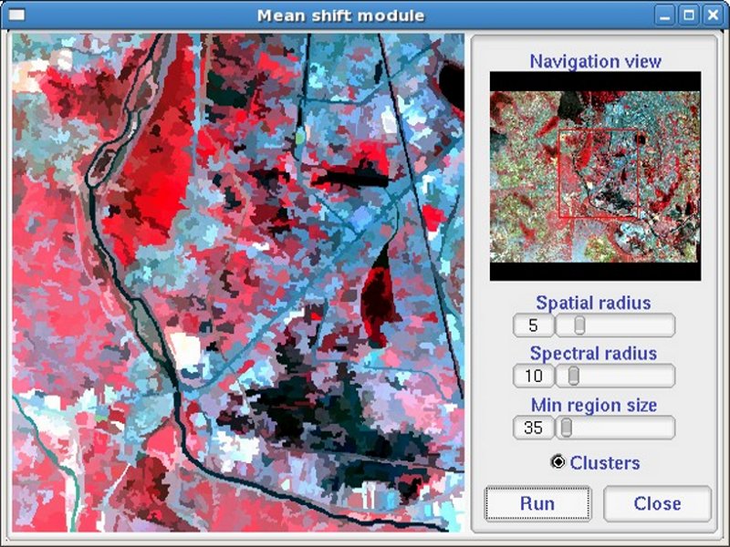
Start Monteverdi from its icon from the Spatial Tools folder on the desktop
Select an raster image, using File ‣ Open Dataset ‣ /home/user/otb/qb_RoadExtract.tif
Go to the Filtering ‣ Mean Shift clustering
Select the input raster image (Reader0) from the input window selection
Verify you can tune parameters of the segmentation and see the result on the region of interest by clicking on “Run”
Select “Close” when you are satisfied by the result.
In the main window, right click on the “Clustered Image” in the resulting dataset “MeanShift0” and select “Display in viewer”
Start Monteverdi from its icon from the Spatial Tools folder on the desktop
Select an raster image, using File ‣ Open Dataset ‣ /home/user/otb/qb_RoadExtract.tif
Go to the Learning ‣ SVM classification
Select the input raster image (Reader0) from the input window selection
You can add classes (Add Class button), select learning samples by drawing polygons in the
Go to the Setup ‣ SVM to set the classification algorithm parameters
Click on the Learn button to create a classification model fron the input learning classes
Click on the Display button to show the result of the supervised classification on the entire image
For the full tutorial see the article.
OTB Software Guide
The main source of information is the OTB Software Guide. This is a comprehensive guide which comprises about 600 pages, detailing the steps to install OTB and use it. Most of the classes available are heavily illustrated with results from real remote sensing processing.
OTB CookBook
A guide for OTB-Applications and Monteverdi dedicated for non-developers is also available.This guide is composed of a brief tour of of OTB-Applications and Monteverdi, followed by a set of recipes to perform usual remote sensing tasks with both tools.
OTB Tutorials
Follow the tutorials to learn more about OTB.
OTB Applications documentation
See also detailed documentation about OTB applications
OTB courses with Pleiades images
Follow the courses to learn more about OTB.