project logo OSGeo Project

MapGuide Open Source

Web Service

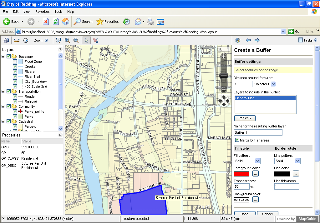
MapGuide Open Source is a web-based platform that enables users to develop and deploy web mapping applications and geospatial web services. MapGuide features an interactive viewer that includes support for feature selection, property inspection, map tips, and operations such as buffer, select within, and measure.

MapGuide includes an XML database for managing content. Maestro allows users to edit the XML database and build a website without writing a single line of code. MapGuide also supports most popular geospatial file formats, databases, and standards.

MapGuide can be deployed on Linux or Windows, supports Apache and IIS web servers, and offers extensive PHP, .NET, Java, and JavaScript APIs for application development. MapGuide Open Source is licensed under the LGPL.

screenshot

Note

Due to space constraints on the DVD, MapGuide is currently not installed.

Core Features

Interactive Map Viewing

  • Dynamic browser-based viewer
  • Feature selection and properties
  • Buffering, querying
  • Printing and Plotting

Quality Cartographic Output

  • Scale-dependent detail
  • Rule-driven thematic stylization
  • Anti-aliased image rendering
  • True color support

Build-in Resource Database for Manageability

  • Hierarchical storage of XML resource documents that define maps, layers, data connections
  • Define data sources and layers once and use them in multiple maps
  • Access-based security model with inheritable permissions

Uniform Data Access

  • Exclusive use of the Feature Data Objects (FDO) API for vector and raster data
  • Provides a standardized way to access a variety of data sources including SHP, SDF, Oracle, MySQL, and PostGIS.

Flexible Application Development

  • Develop your applications in PHP, .NET, or Java

Extensive Server-Side APIs

  • Create, query, read, and write permanent and session based XML resource documents
  • Query and update feature data
  • Perform coordinate reprojection
  • Create, manipulate, and analyze geometry
  • Manipulate runtime maps and layers

Fast, Scalable, Secure Server Platform

  • Fully multi-threaded and takes advantage of multi-core servers
  • Load balancing among servers
  • Pooled database connections
  • Integrated tile caching

Multiple Platform Support

  • Deploy on Microsoft Windows or Linux
  • Serve applications with Apache or Microsoft IIS
  • Browse with Microsoft Internet Explorer, Mozilla Firefox, and Safari and Chrome

Implemented Standards

  • OGC Web Map Service 1.1.1

Details

Website: http://mapguide.osgeo.org/

Licence: GNU Lesser General Public License (LGPL)

Software Version: 2.4.0 Pre-Release

Supported Platforms: Linux, Windows

Commercial Support: http://www.osgeo.org/search_profile

Copyright & Disclaimer