
QGIS mapserver Quickstart
QGIS mapserver provides a web map service (WMS) based on libraries from the Quantum GIS (QGIS) desktop application.
This Quick Start describes how to:
- update an existing QGIS project and render it with QGIS mapserver
- create a new QGIS project and open the WMS directly in a browser
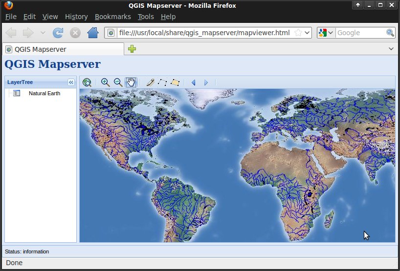
Start GeoExt viewer
OSGeo Live contains an example of web map viewer based on the GeoExt Javascript framework and using QGIS mapserver for rendering the map.
- Click Desktop ‣ Spatial Tools ‣ QGIS Mapserver
You should see a browser window with a web map viewer showing a world map.
We will now change the map styling using QGIS.
Edit QGIS project
- Click Desktop ‣ Desktop GIS ‣ Quantum GIS.
- Choose File ‣ Open Project... from the menu bar.
- Select QGIS-NaturalEarth-Example.qgs and press Open.
- You should see the same world map rendered by QGIS.
We will now change river styling and look at the result in the web map viewer.
- Double click 10m_rivers_lake_centerlines in the Layers tree.
- Change the color in Outline Options to a different blue tone.
- Press OK.
- Rivers are now rendered in a new color.
- Save the project with File ‣ Save Project.
- Reopen the web browser
- Zoom in
- You should now see rivers rendered in the same new color.
Create a new QGIS project
- Reopen QGIS
- Choose File ‣ New Project.
- Click Layer ‣ Add Vector Layer....
- Browse to dataset /home/user/data/natural_earth/10m_admin_0_countries.shp.
- Press Open.
- You should see all world countries.
- Save the project with File ‣ Save Project.
- Use file name /home/user/world.qgs and press Save.
- Open the WMS URL.
- You should see all world countries, this time rendered by QGIS mapserver.
What Next?
To learn more about QGIS mapserver, you can follow the blog articles of Linfiniti or 3LIZ.